Biogeography/Conservation

Plants, animals, and entire ecosystems have inherently spatial and temporal components that are dependent on climatology, elevation, latitude, and more. Describing the distribution and dispersal of various species and their habitats is what biogeography is all about. By incorporating science from various fields such as ecology, biology, chemistry, and geology among others, biogeography is a truly interdisciplinary science. The application of conservation and land/ocean management practices is often an end-goal of biogeography research. I recently worked on a project that examined the shrinking wetlands in the Andean highlands that are used by migratory birds. The goal of the project was to identify the suitable wetlands in the region through remote sensing and ecological mapping and then propose an area to designate as a protected national park. Wildlife corridors are also a common research topic for biogeographers. Corridors in Florida have been protected and/or constructed to connect the habitats of native species. Research by a current masters student at ETSU is utilizing niche modeling to predict the potential distribution for the hellbender - a species of Giant North American Salamander endemic to the Appalachians and Ozarks.
Species Distribution Modeling

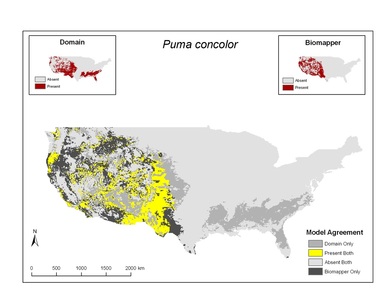
Species distribution modeling, ecological niche modeling, and habitat modeling/mapping are all very important tools used by biogeographers to aid in conservation and habitat management/protection. The map on the right (click to enlarge) was created to identify the potential range of the puma concolor (i.e., puma, cougar, or mountain lion) in the continental United States. The map was produced using a species distribution model (Domain) and a habitat suitability model (Biomapper). Both models perform basically the same task by creating a climate envelope where a species is known to be present then projecting that envelope onto the landscape. Ecological niche models are slightly different than species distribution models and habitat suitability models since they do not always fit the actual distribution of a species. In the case of the GARP ecological niche model, a larger area is predicted on the landscape because the goal of the model is to map the envelope of maximum potential distribution - also known as the fundamental niche of the species. There are many models available for species mapping and several are mentioned in the Open Source/Freeware Modeling & Mapping section. A major benefit of these models is the ability to map past and future distributions (or potential habitats), which can help us understand the potential impact of climate change. Currently, one of my graduate students is using GARP to predict the current and future potential distribution of the hellbender - a species of giant salamander native to the eastern United States.
When referencing text or graphics from this website, please use the following citation: Timothy Andrew Joyner. 2020. www.tandrewjoyner.com. Last accessed ?/?/20??.
